
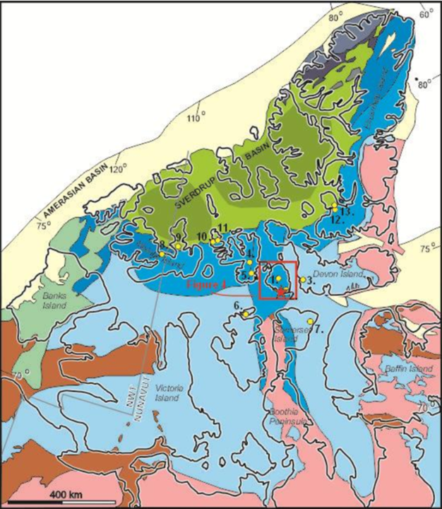
Resolute Bay on Cornwallis Island (source; Geothermal regime of High Arctic communities—Resolute Bay (Qausuittuq), Nunavut, Canada, published May 28, 2026)
Published in the journal Geothermal Energy, the study by Stephen E. Grasby and colleagues demonstrates that earlier data, which suggested thermal gradients as high as 39.4 degrees Celsius per kilometer, were biased by transient thermal responses to post-glacial rebound and specific drilling challenges in thick permafrost regions. The new analysis estimates the local geothermal gradient to be approximately 14.9 degrees Celsius per kilometer based on continuous depth-temperature logs, though regional data suggests it could reach up to 22 degrees Celsius per kilometer. This correction has substantial implications for the community’s energy transition, indicating that while electrical generation remains unfeasible with current technology, direct heat use for community and government facilities may still be a viable renewable option.
Resolute Bay, located on Cornwallis Island in Nunavut, is home to 183 residents according to the 2021 census and serves as a critical gateway to the High Arctic. The community is disconnected from continental power grids and relies on seasonal shipments of diesel, heating oil, and jet fuel to meet its energy demands. With an annual heating load reported at 5,690 megawatt-hours and electricity demand of approximately 4,500 megawatt-hours, the community faces significant economic and environmental challenges associated with imported fossil fuels. The extreme climate, characterized by a mean annual air temperature of minus 15.1 degrees Celsius and 24 hours of darkness for 89 days a year, severely limits the viability of solar and wind energy, making geothermal energy a subject of considerable interest for enhancing energy sovereignty and reducing the carbon footprint.
The study integrated historical well records with new data collection from cores, field work, and remote sensing to develop a more accurate conceptual model of the subsurface. A key finding was the identification of systematic errors in previously reported thermal gradients, which were attributed to the unique conditions of drilling in regions with thick permafrost. The researchers noted that the high thermal gradients reported in the 1950s by Misener (1955) were likely the result of the ground still re-equilibrating after the rapid warming and post-glacial isostatic rebound that occurred around 10,300 years ago. This rebound caused a relative sea-level drop, changing surface conditions from subsea to subaerial and propagating a cold front into the ground, which created an apparent transient thermal gradient much higher than the true equilibrium state.
To determine the actual thermal conditions, the team analyzed detailed temperature logs from the Resolute Bay L-41 petroleum exploration well, drilled 1.7 kilometers east of the community. The well recorded a bottom-hole temperature of 40 degrees Celsius at 1,474 meters, but the researchers determined this value was erroneous, reflecting temperatures near the top of the well rather than the bottom due to the circulation of 75-degree Celsius drilling mud during operations. A detailed temperature log taken after drilling showed a cooling trend down to minus 4 degrees Celsius at 200 meters, followed by a gradual warming to 0 degrees Celsius at approximately 516 meters, which the researchers identified as the base of the permafrost. Below this depth, temperatures increased to a maximum of 12.6 degrees Celsius at the total depth of 1,473 meters, yielding a geothermal gradient of 14.9 degrees Celsius per kilometer for the lower portion of the log.
The geological model constructed for the area reveals a complex stratigraphy dominated by Paleozoic sedimentary rocks deposited on the Franklin Margin. The subsurface sequence includes the Allen Bay, Irene Bay, Thumb Mountain, Bay Fiord, Eleanor River, Baumann Fiord, and Cass Fjord formations. The study found that matrix porosity and permeability are generally low across these formations, with average total porosity ranging from 0.7 percent in the Allen Bay Formation to 11 percent in the Irene Bay Formation. However, high total porosity does not always translate to reservoir quality; for instance, the Irene Bay Formation has an average effective porosity of only 0.7 percent due to its high shale content. The Bay Fiord Formation offers the highest porosity with zones of up to 10 percent effective porosity, but it occurs at shallow depths where temperatures are likely below 16 degrees Celsius, limiting its utility for high-temperature applications.
Fracture networks appear to be the primary mechanism for potential fluid flow in this tight reservoir system. Remote sensing analysis of a high-resolution digital elevation model revealed a dense concentration of faults within the Allen Bay Formation, consistent with two recorded loss-of-circulation events in the L-41 well. Field measurements from outcrops of the Eleanor River Formation showed an average fracture spacing of 0.43 meters, with a prominent northwest-southeast fracture set. While fracture permeability values ranged from 25 to 950 millidarcies, the researchers noted that these surface measurements may not be preserved under subsurface reservoir pressure, introducing uncertainty into flow predictions. The complex rock fracture system likely dominates fluid flow, but its spatial variability and mechanical fragility at depth remain significant challenges for geothermal development.
The high thermal conductivity of the Baumann Fiord Formation makes it a candidate for closed-loop geothermal systems, where a working fluid is circulated in a closed system to extract heat without relying on rock porosity or permeability. In contrast, the Cass Fjord Formation has the lowest measured conductivity at 2.4 watts per meter-kelvin. The study suggests that a closed-loop system with a horizontal leg through the Baumann Fiord Formation could connect the community and the nearby government installations at the airstrip, which are approximately five kilometers apart. This configuration would maximize exposure to the high-conductivity evaporite units and could utilize thermal syphons to reduce lifting costs and heat loss.
The researchers concluded that the local geothermal gradient of 14.9 to 22 degrees Celsius per kilometer precludes electrical generation with current technology, as depths greater than five kilometers would be required to reach the temperatures necessary for even low-efficiency binary systems. However, direct heat use remains a promising avenue for meeting the community’s heating demands. A conventional open-hole system would need to reach depths between 1,800 and 2,500 meters to obtain temperatures between 20 and 30 degrees Celsius. While the low permeability of the carbonate mudstones would reduce production rates, intersecting fracture systems could enhance fluid flow. The study emphasizes that previous economic and technical assessments of geothermal potential in Resolute Bay, which relied on higher thermal gradients, require reanalysis to reflect the more conservative and accurate data presented here.
Fluid chemistry data from drill stem tests revealed Na-Cl type waters with total dissolved solids ranging from 33 to 74 grams per liter, with some samples showing salinities up to twice that of seawater. These high chloride concentrations could pose corrosion and scaling issues for conventional geothermal systems, adding another layer of technical complexity to potential development. The study highlights the importance of integrating geological, thermal, and hydrochemical data to develop a robust conceptual model for geothermal exploration in the High Arctic. By correcting the systematic overestimation of thermal gradients, the research provides a more realistic foundation for future exploration and development decisions, balancing the community’s need for renewable energy with the technical and economic constraints of the region.
The findings underscore the unique challenges of geothermal exploration in regions with thick permafrost and post-glacial thermal histories. The systematic errors identified in previous studies serve as a cautionary example for other Arctic communities considering geothermal energy. The study by Grasby and colleagues offers a detailed roadmap for assessing geothermal resources in similar geological settings, emphasizing the need for continuous temperature logging and careful interpretation of historical data to avoid overestimating resource potential. This work contributes to the broader goal of developing resilient and reliable on-site energy solutions for the Arctic, where the harsh environment demands innovative and well-informed approaches to renewable energy deployment.
Article Title: Geothermal regime of High Arctic communities—Resolute Bay (Qausuittuq), Nunavut, Canada
Article References: Grasby, S. E., Williscroft, K., Yuan, W., Dewing, K., Hu, K., Witter, J., Farrell, S. P., & Hedhli, M. (2026). Geothermal regime of High Arctic communities—Resolute Bay (Qausuittuq), Nunavut, Canada. Geothermal Energy, 14(1), Article 15. https://doi.org/10.1186/s40517-026-00387-4